


1. Background
The Intergovernmental Panel on Climate Change [1] has claimed that sea level is rising and that an additional acceleration is soon to be expected as a function of global warming. This proposition only works if the present warming would be a function of increased CO2 content in the atmosphere (a hypothesis termed AGW from Anthropogenic Global Warming). On a longer-term basis, it seems quite clear, however, that the dominant factor of global changes in temperature is changes in solar variability [2-3]. Regardless of what actually is driving climate change and sea level changes, the proposition of a rapidly rising sea level grew to a mantra in media and politics. This initiated a flood of papers rather based on models and statistics, however, than on actual field observations.
The Fiji government will be the chair-nation at the next international climate conference; COP23 in Bonn in November 2017 [4].
This paper represents a detailed analysis of available field observation on sea level changes in the Fiji Islands over the last 500 years.
2. Methods
The Fiji Islands consists of over 300 islands. From a survey of available literature(e.g. [5-8]), the Yasawa Islands were chosen for our field studies [9]. On Google Earth it is now possible to examine coastal segments in quite a great detail, and to select promising sites for field studies at ground. Ten sites on the Yasawa Islands were selected [9], because it seemed possible to investigate also the sea level changes during the last 500-600 years (a period not covered by previous studies).
At site, we explored the morphological structures in view of past and sub-recent sea level changes. The high tide level (HTL) was generally marked by distinct features like shore notches, under-cut notches, sea caves, rock-cut platforms and sandy shore morphology. This level was chosen as our zero level for measurements. The mean tide level (MTL) and low tide level (LTL) were explored and measured as to elevation. Leveling was undertaken with a high precision Kern instrument with a reading accuracy better than 1 cm.
Samples were collected, 17 of which were radiocarbon dated (at the Uppsala AMS dating laboratory).
At several sites, we observed coral grown into “microatolls” because of stable sea level conditions. The controlling water depth was sharply measured to 40 cm below LTL.
3. Results
On the main island of Viti Levu, there are two tide gauge stations. We analysed their location, susceptibility to compaction of the marine soft sediment upon which the harbour constructions are resting, and the location and implication of nearby GPS readings [10]. Both sites are very unfortunately placed on heavy wharf constructions resting on soft marine sediments. The load is likely to induce site-specific compaction. In addition, there may be a weak regional crustal subsidence factor.
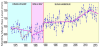
The Suva station has often been used as some sort of Fiji standard of a long-term trend from 1972 to the present [11]. This is a serious mistake, however, because the record is cut in 3 incompatible segments from 3 different locations of the tide-gauges. This is illustrated in Figure 1 [10] revealing that the record, in fact, comes from three different tide gauge stations. The present location is from 1989. The record does not provide any mean trend, but a dynamic variability between 16 years of stability, 10 years of sea level rise and 4 years of sea level fall. Hence, there is a lack of evidence of a present rise in sea level.
We also analysed some sites of coastal erosion in Yasawa Islands [12]. In no case the erosion was initiated by sea level changes but by human interference with the coastal sedimentary conditions.
Our main sea level investigation was on the Yasawa Islands with the focus on sea level change during the last 500 years. A comprehensive presentation is given elsewhere [13], with a shorter summary in [14].In this paper we highlight the main findings, which can be summarized in 3 steps from about 1450 up to today (2017) as illustrated in Figure 2.
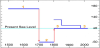
- a +70 cm level in the 16th and 17th centuries
- a -50 cm low level in the 18th century
- a level at about ± 0.0 cm in the 19th, 20th and 21st centuries probably with +30 cm peak in early 19th century, and a 10-20 cm lowering in the late 20th century but with strictly stable condition in the last decades
The +70 cm is very well established by an elevated beach and a bedrock notch both levelled with an accuracy of 1 cm. In addition there are several old shore terraces at an elevation of about 0.5 to 1.0 m above present sea level. Two C14-dates provide a calibrated age (with a marine reservoir effect of 450 ±30 years) of AD 1601 ±143 and 1576 ±71, respectively.
This high level was followed by a low level with the HTL displaced to a position of about 20-30 m above present LTL. This corresponds to a mean sea level of about -50 cm. This low level seems to have occurred in the 18th century. At present, we lack any strict C14-date, however.
Then followed a period of continual formation of extensive spits and spurs. Three of those were levelled in detail [13]. A shore spur at Naisisili Village on Nabukeru Island is 155 m long. The spur crest is about 30 cm higher for the first 50 m and then remains quite flat at an elevation of about 50 cm above HTL. Shells taken 30 cm below the surface at the innermost part of the spur was dated at AD cal. 1866 ± 82, suggesting that the spur was built our at a mean rate of about 1.0 m per year, which seems reasonable. A shore spur at Gunu Village on the Malevu Island has a double spur system. The elevation remains more or less constant at 40-50 cm above HTL over its length of about 150 m. Shells at a depth of 40-50 cm below the surface at a point 47 m from the onset of spur formation were dated at AD cal. 1910 ±40. Both sites strongly support stable sea level conditions over the last 150 to 200 years. In the first 50 years or so, sea level might have been about 30 cm higher than today, however.
In the last 50-60 years, there might have been a 10-20 cm sea level lowering, judging from the difference between dead Patella shells and living Patella shells on shore blocks at Denarau on Viti Levu [13], and the forced conditions for corals on Yasawa Islands to grow into microatolls dated as younger than AD 1955. The 1998 ENSO event may also have caused extensive coral breaching. If this would have been the case, we see very strictly stable sea level conditions in the last 15-20 years, because so many corals at multiple sites are forced to grow laterally into microatolls.
Figure 2 gives the combined documentation of sea level change during the last 500 years in the Fiji Islands.
4. Discussion
We revised the records from the two tide gauges on the main island of Viti Levu [10], and showed that location must be seriously analysed with respect to site-specific compaction of loose marine deposits beneath the heavy harbour construction upon which the tide gauges are attached. At Suva, there is another serious problem in the fact that the location of the tide gauge has been moved. This gives 3 independent segments (Figure 1). It is a serious mistake to combine all three records into one, and give a mean rising trend from 1972 to the present [11]. Even the record from the last site in Suva harbour, now covering 28 years, gives a very unclear picture (Figure 1).
No previous investigation has covered the sea level changes of the last 500 years. In this respect our Yasawa Island investigation [13] is unique.
The Yasawa Island investigation provided a clear picture of the sea level changes during the last 500 years (Figure 2): a +70 cm higher sea level, a -50 cm lower sea level and a stable sea level (with some possible ups and downs) for the last 150-200 years. Most important; there is a clear absence of a present sea level rise (completely contrary to [1], but in full agreement with [15]).
The long-term changes during the last 500 years – i.e. a high, a low and a present level – is recorded in the Maldives [16], in Bangladesh [17-18] and in Goa, India, [15,18], as illustrated in Figure 3. A present long-term stability is also recorded in Qatar [19].
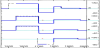
The general agreement between the observed sea level changes in Fiji during the last 500 years, and those recorded in the three Indian Ocean sites: the Maldives, Goa and Bangladesh is striking, which is a very strong (even conclusive) argument that the recorded sea level change are of regional eustatic origin [20].
All four records show a high in the 17th century (which was a period of Little Ice Age conditions), a low in the 18th century (which was a period nearly as warm as today) and a high in the early 19th century (which was the last period of Little Ice Age conditions). This means that the Figure 3 sea level changes are almost directly opposite to the general changes in global climate. Consequently, the eustatic changes recorded cannot refer to glacial eustasy, but must be understood in terms of rotational eustasy.
This calls for some explanation. The idea that oceanic water masses may be dislocated horizontally by rotational–dynamical forces was launched in 1984 [21] and more extensively presented in 1988 [22]. Later, is was proposed that changes in the Solar Wind strongly affects the Earth’s rate of rotation [23] (with a deeper analysis in [24]) leading to a beat in the Gulf Stream with alternations between a dominant northeastward flow during rotational slowing-down periods of Grand Solar Maxima, and dominant east-south eastward flow during rotational seeding-up periods of Grand Solar Minima [25].
The sea level changes in the Indian Ocean, were therefore proposed [26,15] to be driven by rotational eustasy; i.e. the interchanges of water masses between high-latitudes and the equatorial region as a function of the speeding-up during Grand Solar Minima with Little Ice Age conditions and slowing-down during Grand Solar Maxima with generally warm climatic conditions.
In the post-Little Ice Ages period from 1850 up to 1930-1940 there was a global glacial eustatic rise in the order of 11 cm [28]. For the rest of the last 500 years, rotational eustasy seems to have been the dominant factor as documented in Figure 3 and illustrated in Figure 4.

5. Conclusion
Previously, the changes in sea level during the last 500 years were not covered by adequate research in the Fiji Islands. The present paper provides a detailed analyses documenting a +70 cm high level in the 16th and 17th centuries, a -50 cm low in the 18th century and a period of virtually stability in the 19th to early 21st centuries, the last period of which may be subdivided into an early 19th century +30 cm high, a long period of stability and a 10-20 cm fall in sea level in the last 60 years forcing corals to grew into microatolls under strictly stable sea level conditions. This means there are no traces of a present rise in sea level; on the contrary: full stability.
The long-term trend is almost identical to the trends documented in the Indian Ocean in the Maldives, Goa and Bangladesh. This implies a eustatic origin of the changes recorded; not of glacial eustatic origin, however, but of rotational eustatic origin.
The rotational eustatic changes in sea level are driven by the alternations of speeding-up during Grand Solar Minima (the Maunder and Dalton Solar Minima) forcing water towards the equator, and slowing-down during Grand Solar Maxima (in the 18th century, around 1930-1940 and at about 1970-2000).
Competing Interests
The author declare that there is no competing interests regarding the publication of this article.
Acknowledgments
I acknowledge the perfect assistance in the field by Pamela Matlack- Klein, co-author of all the basic Fiji papers of the project [9,10], [12,13]. The project was made possible thanks to kind support of the CO2 Coalition. This paper represents the content of a paper presented at the 4th World Conference on Climate Change in Rome, 2017 [14].